
Editor's note: Adam Kritzer is a longtime Dali resident and founder of ClimbDali, a company offering guided outdoor trips and adventures in and around the Dali area.
The Gaoligong Mountains (高黎贡山) are around 500-kilometers long, and run north to south near the Yunnan-Myanmar border. They form the western wall of the Nu River Valley. There are numerous trails that cross the range, several of which are already on the radar of Chinese hikers.
Our goal for this particular weekend in March was to follow one trail — a section of the Southern Silk Road (南方丝绸之路) that connects Baoshan (保山) with Tengchong (腾冲) and was rumored to be relatively well-preserved.
We caught a bus traveling west out of Dali and got off immediately after it crossed the Nu River (怒江), about one hour past Baoshan. From there, we were able to hitchhike the final 40 kilometers without much difficulty. Our driver deposited us at Shuanghong Bridge (双虹桥), which marked the starting point for our hike.
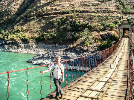
The bridge spans the Nujiang in two separate sections and is one of only a handful in Yunnan that have not yet been submerged or fallen into disuse due to neglect. It was originally built in 1789 and crosses the Nujiang at a point where the river is relatively slow-moving.
After stopping to view the bridge most hikers charter a minivan to take them up a new concrete road that leads to Baihualing (百花岭) and the official trailhead. We resisted the temptation to stray from the path and made our way due west into the mountains following the original trail. We quickly reached a village and inquired about the possibility of following the original trade route, but were told our only option was to walk along the new road.
Fortunately, we ignored this advice and after an hour of light bush-whacking, we were rewarded with an excellent section of the original trail. We stopped to chat with a local coffee farmer — coffee being the dominant crop in the area.
We continued up the hill to Big Fish Pond Village (大鱼塘村) and were invited in by a local family for some tea. When asked if they had any coffee, they told us they didn't have the means to prepare it, which was a bit ironic given the massive pile of unshelled coffee beans in their courtyard.
We learned from locals that they command a wholesale coffee bean price of only eight yuan per kilogram. Despite this low price, it seemed the village was fairly prosperous and had begun to make the transition from mud brick to concrete houses.

As it was getting late, we politely excused ourselves and continued in search of accommodation. We walked past sign after sign advertising agritourism inns (农家乐) and settled on an unnamed place to stay at the end of the road. Our dinner there was not only fresh and flavorful, at 40 yuan it was also a steal for four dishes and rice.
We sat down for some conversation with the other guests — a wealthy couple from Guangzhou who had come for some fresh air and a group of retirees from Hunan who wanted to take photos of birds. There were also a handful of flags from hiking clubs around China hanging above us, which we took to be an indication of the trail's popularity.
The guesthouse proprietor inquired about our hiking permits, to which we responded that we had not purchased any. Having done some research beforehand, we were aware of the permit requirement, but also understood that permits were available free-of-charge in Baoshan. We made it clear that we had no intention of paying for one.
Our host cheekily escorted us across the road. His neighbor worked for the forest department, and asked us for a small "voluntary" contribution for his efforts to keep the trail clean. We later found that not only was the man not a representative of the forestry department, it seemed no one was in charge of trash collection as the route we would take to the trailhead the following day was strewn with garbage.

We awoke at sunrise the next morning, ate a hearty breakfast of rice noodles, and began hiking up the mountain. Again we were told the only way up was to follow the cobblestone road for the first six kilometers, and again we ignored such counsel and set off into the forest in search of the original trail.
A new tractor road ran alongside, and at times, in place of our chosen path. After an hour, we reached the official trailhead, marked with a handful of signs. We were startled to discover a small group of Belgian birdwatchers who had traveled from Beijing. It wasn't long before we realized why they were willing to make such a long trip.
Perhaps because they are part of the Three Parallel Rivers of Yunnan Protected Areas, the forests of the Gaoligong moutains are among the most spectacular we have seen in China. They contain a surprising mix of old-growth hardwoods, rhododendrons, ferns, and numerous other plants. Signs along the trail warned of leaches, but we imagine this would only be an issue during the summer rainy season.

The forests are also home to dozens of bird and mammal species, though we didn't come across anything larger than a squirrel. We also did not see any illegal logging or hunting while we were hiking — a testament to the efforts to protect the area.
As we had hoped, the trail itself is almost completely intact, consisting of large and small flagstones that must have required considerable effort to put in place. This section of trail offers what is perhaps one of the purest experience of walking along an authentic caravan route in Yunnan.
After a few hours, we reached a bridge and refilled our water bottles from the crystal-clear stream that surged beneath it. Two hours of very steep climbing brought us to the top of the mountain. We checked our altimeter and it read 3,150 meters.
We had gained more than 2,400 meters of elevation over the last day-and-a-half to reach this point. We paused at the pass to rest at a free public way station — called a nanzhai gongfang (南斋公房) in Chinese. Apparently, the house was built and is maintained by daoist priests — hence the name — as a rest stop for passing caravans. The house itself was picturesque, but piled with garbage, and not really a suitable place to spend the night.

Upon crossing the pass, we reached a World War II-era bunker that was signposted as such. Apparently the Gaoligong mountains were the site of numerous battles between Chinese/Allied and Japanese forces, which including one skirmish at the highest elevation of the entire war. This particular bunker was only big enough for one or two soldiers, with a small gunsites in the front.
From there, the trail wound down the mountain through a steep canyon before the land flattened noticeably. The rhododendrons had already begun to flower, which made for excellent photo opportunities. As we neared the valley, we passed a dense thicket of bamboo and very nearly lost the trail.
In the early afternoon, we arrived at Linjiapu (林家铺), which marked the end or beginning of the trail depending on which direction people are heading. It was marked by a simple forest ranger station. We endured a few minutes of mild dressing-down that included threats of fines for not having the proper permits and then continued down the mountain.
This time, the locals were right when they told us that the new dirt road had completely obliterated the old route and that we were better off hiring a van or motorcycle to take us the rest of the way. We stubbornly forged ahead on foot, and proceeded to get terribly lost following cow paths that led into swamps and footpaths that petered out in cornfields.

We soon reached a small clearing, where an elderly man who appeared to be blind had somewhat incredibly managed to erect a makeshift wooden house. He looked to be living completely off the land, alone. He politely refused to pose for a photo and directed us back toward the road.
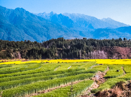
The area was quite scenic and contained fields of golden rapeseed in full bloom set against bamboo groves and the towering peaks of Gaoligong Mountains. However, walking on a dirt road that had no shade under the searing mid-day sun ended up being far from pleasant. We managed to flag down a small truck for the final few kilometers into the town of Jiangju (江苴).
The village had a well-preserved old main street and an equally interesting rebuilt main street. Sometime in the past, Jiangju was most likely an important staging point for the Gaoligong crossing. The town is evidently trying to rekindle its glory days by positioning itself as a tourist destination, much like Shaxi or Shaunglang.

Getting there
There are direct buses from both Kunming and Dali to Baoshan. From Baoshan you can reach Mangkuan (芒宽) or Liuku (六库). Tell the driver in advance that you want to get off at the road that leads up to Baihualing.
You can expect to spend more than 100 yuan to charter a minivan up to Baihualing or alternatively spend three or more hours walking. Return buses from Tengchong are frequent, though buses to Tengchong from the end of the trail in Jiangju are much less-so.
Farmhouse-style inns are plentiful in Baihualing and run 60-80 yuan per room. The village has a handful of small shops, though it would make more sense to stock up on provisions in Baoshan.
There are places to camp outside the village. Although the only logical point along the trail for camping is near the small dwelling at the pass, which is conveniently located nearby a small spring.
As for arranging the hiking permit, you should contact Xiao Lin (小林) at 13987053498 on the Baoshan side or call 15287564229 on the Tengchong side for specifics. The permit itself can be obtained in either Baoshan City or in Qushi (曲石乡) free of charge.
Images: Adam Kritzer
© Copyright 2005-2026 GoKunming.com all rights reserved. This material may not be republished, rewritten or redistributed without permission.


Comments
Great post, thanks for telling us about this area.
I'm a little confused about the timeline. Was this entire hike accomplished in one day, without camping on the mountain?
The original Shuanghong Bridge was even older - dating to the early 1500s. The 1759 one standing now is a reconstruction. Chinese reconstruction has been going on for some time!
I'm not sure all 农家乐 would qualify as "agrotourism". A lot of them seem to be just normal restaurants which happen to be on the outskirts of town. Not saying the ones in 百花岭 aren't, just that in general not all 农家乐 are.
I want to do this hike. Thanks for the report!
Ditto on the great hike/article post! I've been wondering how popular these mountains are for hiking.
Had the same question as Geogramatt about the total time for this hike. Just as much, anyone have any estimates about how much time is needed to do this round-trip from KM?
Also, references such as "a surprising mix of old-growth hardwoods, rhododendrons, ferns, and numerous other plants" really titillate my fancy. Anyone have a lead as to where more detailed information on flora (and fauna) of Yunnan can be found in English?
Actually, the bridge was built in 1789 and rebuilt in 1923. (My apologies for the typo). Extant records indicate that prior to that, caravans crossed the nujiang at that point on foot.
We completed the hike in 2 days from start to finish (with a night spent at a 农家乐); you could do it in 1 long day, or attempt to camp. Unfortunately, the only suitable campsite is at the top of the mountain, but that area is littered with garbage.
The typo on the date of construction for the bridge has been fixed.
I wanna do this hike, but how more precisely do you find the original path, that you guys got to through some "light bush-wacking"?
And are their accomodation possibilites spread out along the trail, or do you need to time your treck so that you reach a particular place in the evening?
Login to comment