
Editor's note: The following article was authored by GoKunming contributor Matthew Hartzell. Hartzell works as a guide for Zouba Tours, bringing guests to Yunnan's less-traveled places, like Xinping. He also maintains an extensive travel blog (requires proxy).
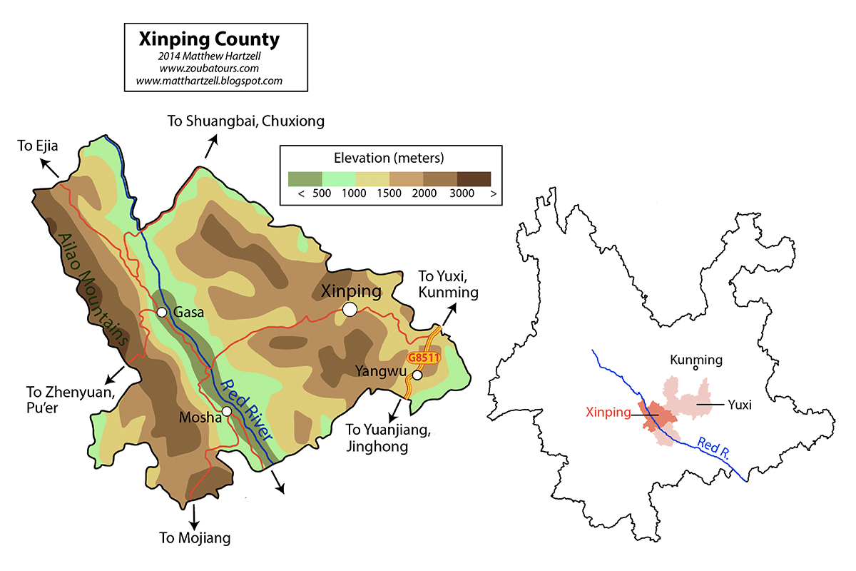
Situated smack dab in the center of the province but off of the main transit corridors, Xinping Yi and Dai Autonomous County (新平彝族傣族自治县) is a place that deserves to be better known. Its fertile Red River valley, home of the Flowery Waist Dai (花腰傣), is a slice of Xishuangbanna-esque tropical paradise just three hours from Kunming. The basin is flanked on either side by vastly different terrain — a plateau populated by Yi people on the east, and a nature reserve and biodiversity hotspot on the west.
Xinping isn't so much a place you go for any titular destinations, but the traveler passing through its territory is unlikely to be disappointed. It is close enough to Kunming for a short getaway but is also strategically positioned between Kunming and destinations further south such as Pu'er, Honghe or Xishuangbanna. Most places in Xinping are accessible by bus, but the best way to experience the region and its beauty, for us at least, is by bicycle.
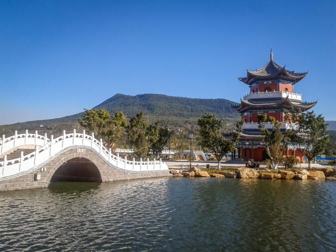
The most common way to reach Xinping is via the G8511 Expressway, which runs through the eastern corner of the county. At the turnoff in Huanian (化念), about halfway between Yuxi (玉溪) and Yuanjiang (元江), Provincial Highway 306 climbs 30 kilometers up onto a plateau where Xinping's county seat is located. The town is nothing too special — just a quiet place with a pagoda on a hill and a pleasant lakeside park just to the west.
Continuing west, one crosses a small summit before beginning a thrilling 45-kilometer descent into the valley below. Travelers may be familiar with other descents — the truck-clogged national highway to Yuanjiang, the horribly-surfaced road from Jianshui (建水) to Nansha (南沙), and the arid descent from Gejiu (个旧) to Nansha. But the road from Xinping is by far the best of the bunch.
The tarmac is brand new, sees little traffic and incorporates an engineering oddity usually reserved for railroads — a 360 degree loop. The scenery gradually becomes more and more tropical as gusts of warm air issue up out of the valley. Roadside stands sell bananas, mangos, and pineapples — a sure signal that one has entered the tropics.
The Red River (红河) itself, here flowing at just 500 meters above sea level, seems underwhelming on first glance — a shallow stream of water one could walk across depending on the season. Unlike the other major rivers in the province — the Jinsha, Lancang, and Nujiang, which all begin on the Tibetan plateau — the Red River begins within Yunnan's borders, and thus has little chance to accumulate much volume before this point.
At the Red River Bridge one has two choices. The first option is to cross, climb up a hill and then take an older road either north towards Gasa (戛洒) or south towards Mosha (漠沙). Alternately, one can take the much faster and smoother new road which follows the right bank of the river to Gasa. According to the dictionary, the character '戛' is pronounced 'jia', but locals all say 'ga' in their dialect. Regardless of the name, it is the second-biggest city in the county, and a fun place to spend the night.
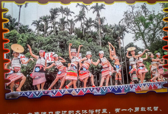
The town has quite a bit of money from agriculture and mining, and boasts several hotels and restaurants as well as an attractive walking street lined with bars and cafes. There it is not unusual to spot Flowery Waist Dai women in full regalia, either at the weekly morning market or the village square. In other parts of Yunnan it's often only the older ladies who dress up on a regular basis, but here young women do as well.
Extending down the valley to Mosha and on into Yuanjiang is the heartland of the Flowery Waist Dai. They share in common with other Dai a language family called Tai-Kedai, as well as historic origins to the north. But while waves of migration over the centuries brought most Dai people deep into Yunnan and all the way down into Laos and Thailand, the Flowery Waist Dai decided that the basin was good enough to call home and settled down here.
When Theravada Buddhism spread to Southeast Asia and Xishuangbanna, it never managed to cross the Ailao Mountains, and thus the Red River Dai to this day are animist, spirit-worshipping and decidedly non-Buddhist. As such, the Buddhist Water-Splashing Festival was not typically celebrated in the area. But since the Chinese government fabricated the notion of a single Dai ethnic group upon which tourism development strategies are based, the Flowery Waist Dai of Xinping have recently begun to incorporate water splashing into their own Flower Street Festival (花街节), held annually in March.
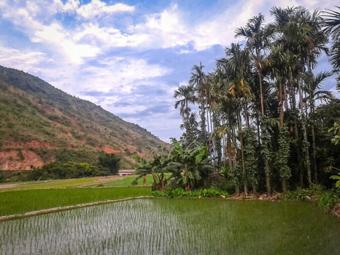
In costume, as their name suggests, the Flowery Waist Dai prefer intricately embroidered waistbands, silvery bangles, and large straw hats. The area's architecture is also unique. Mud brick, flat-roofed houses predominate instead of the more typically Dai bamboo stilt houses. Agriculturally, Xinping's Red River valley looks like the plains of Xishuangbanna before they were turned into rubber plantations in the 1950s.
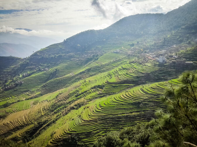
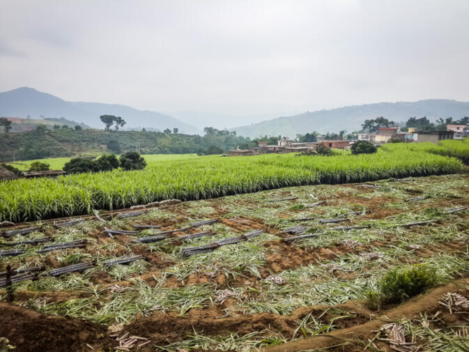
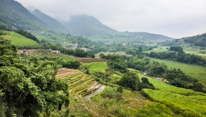
Traveling south through the canyon towards Mosha, one passes through an idyllic landscape of rice paddies, fields of sugarcane and bitter melon. Those give way to orchards of lychees, oranges, and mangoes. Although the valley receives little rainfall, crops are fed by the year-round springs and streams of the Ailao Mountains that tower above everything. Because of this, Xinping's farmers manage to grow up to three crops of rice annually.
At Mosha, a quiet town perched on a slope above the river, the road splits in two. One can either continue along the river to Yuanjiang and there rejoin the G8511 Expressway, or turn off on a winding road over the Ailao Mountains that leads to Mojiang (墨江). Below Mosha, at the river's edge, is the pretty village of Damuyu (大沐浴), which bills itself as something called an 'ecological village' (生态村). The place has a small museum and other travel infrastructure, although every time we've visited we've been the only tourists there.
Back in Gasa, if one were to proceed north rather than south, one would have three different choices of route. Provincial Highway 218 leads up the Lüzhi River (绿汁江) to Chuxiong (楚雄). Provincial Highway 307 climbs two thousand meters up into the rich temperate forests of the Ailao Mountain Range. Yet another road continues up the Red River valley.
Across the county border, in a remote corner of Chuxiong's Shuangbai County (双柏), it reaches a remote town called Ejia (鄂嘉) which is inhabited by Yi people and celebrates the infamous Breast-touching Festival (摸奶节) in July. Local legend has it the unmarried women of Ejia allow men of their choosing to touch their breasts once a year, in order to ward off the ghosts of long-perished soldiers, who would otherwise prey on the village's 'untouched' girls.
North of Ejia, the thus-far well-maintained tarmac becomes a poor unpaved road as it continues winding along the Ailao Mountains. The dirt track meanders high above the Red River, heading north through spectacular rice terraces and remote villages of Chuxiong, Nanhua (南华) and Midu (弥渡) counties. Eventually it meets up with the Dali-Lincang highway in Nanjian (南涧) near the source of the Red River. It's possible follow this road by bicycle, as we did, but it's a major test of endurance.
An equally challenging ride, but one on full pavement, is the aforementioned Highway 307 over the Ailao Mountains. This mountain range, though not particularly tall compared to the mountains of northwest Yunnan, is nevertheless one of the most distinguishing geographic features of the province. Of all the sub-ranges of the Himalaya's Hengduan Mountains (横断山), the Ailao range is one of the most dramatic.
Extending in a nearly perfect diagonal line from northwest to southeast, parallel to the Red River, it is home to the endangered golden snub-nosed monkey, the famous rice terraces of Yuanyang (元阳), and the Hmong hill tribes of Sapa, Vietnam. Here in Xinping, the upper reaches of the mountain range are home to untampered and diverse old-growth forests protected in a national level nature reserve.
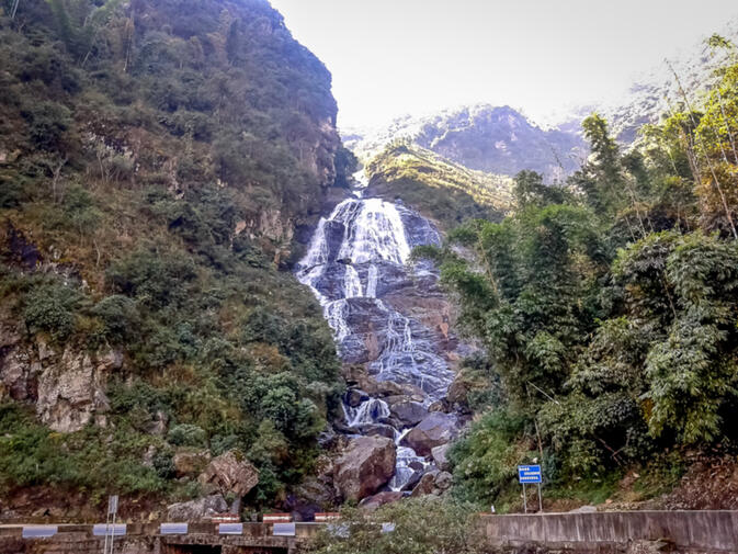
Scenic spots along the road include the Nan'en Waterfall (南恩瀑布) and Shimen Gorge (石门峡) — a lush valley with walking paths along a river through the forest. The final ascent to the summit is a steep one, and significantly colder than the tropical area below. The ridgeline forms the border between Yuxi and Pu'er (普洱) Prefectures. From here one can proceed west into Pu'er Zhenyuan County (镇沅县) and from there either north to Jingdong (景东), west to Jinggu (景谷), or south to Simao (思茅).
Getting there
Six daily buses from Kunming's South Bus Station (南部客运站) head to Xinping. Tickets cost 70 yuan and the trip takes roughly three hours. The other major towns, Gasa and Mosha, are well-connected both to Xinping Town as well as to neighboring counties such as Yuanjiang, Mojiang, and Shuangbai. Buses connecting Chuxiong to Pu'er run through the county as well.
All images and map: Matthew Hartzell
© Copyright 2005-2026 GoKunming.com all rights reserved. This material may not be republished, rewritten or redistributed without permission.


Comments
Good season of traveling around NY.
Another great article Mr. Hartzell! I've got a couple of questions and perhaps you (or others) can answer:
1.) What are the names of these 'national forests' with old growth forests? I've been to Mopan Mountain National Forest Park (磨盘山国家森林公园), but I did not see any old growth. Perhaps I didn't look hard enough (pun intended!).
If anyone has extra links/info about old growth forrests/parks in Yunnan, please enlighten. It's been a little difficult for me to locate them outside of Deqin/Nujiang.
2.) Where is the exact origin of the Red River and what are the most popular 'local' variations of its name? Is it 'West River' NNW of Weishan (what I thought but others have questioned)?
Thanks for any info!
Heres a few helping words (if they may help at all). Theres a mapbook of Yunnan - primarily for drivers - that shows tourist locations and the Red River 起点, in other words, where is the Red Rivers starting point. This is probably just a matter of definition, and whether the drought has changed the location is yet another question. Theres an old bridge too with a nickname (something like) "The first bridge over Red river", but no water floats under it anymore. It might have been demolished too - who knows.
Yea, its Weishan area. Head up to the location where the old Moslem Town of Donglianhua is, its in those areas, maybe a bit further up.
Old maps may also give some ideas here, about the "real name". Plenty of places, rivers etc. have had their names changed during the last 100 years. There used to be many "Tiger Mountains" around.
Heres a link that shows the area. What you are looking for is "Honghe Yuantou" 红河源头.
wqp526.blog.163.com/blog/static/97554536201292192627350/
Thanks for the great article! You've reminded me how much I miss the countryside.
The Yangtze river used to flow southwards (from Lijiang) into the valley of the Red river prior of the uplifting of the Yunnan plateau. A theory which is researched / studied.
I didn't have a chance to visit Mopanshan, so can't comment as to the forests there.
The old growth forest is in Ailaoshan National Nature Reserve, which, as its name implies, runs along the Ailaoshan Range.
It's definitely not all old growth. A driver friend of mine used to haul lumber off the mountain in the 80s. On Google Earth you can see various rural roads snaking up into the mountains, so most of the logging probably would have taken place close to these. But most of the mountain range is pretty inaccessible, and it's here that the older trees, and animals, are most likely to be found.
As others have already answered, the Red River's source is in Dali's Weishan County 巍山, where it's little more than a trickle. The Red River had at least three different names within Yunnan that I know of:
Lishejiang 礼社江
Yuanjiang 元江
Honghe 红河
Login to comment