Quick Menu
China has more than its fair share of beautiful natural landscapes, and it's burgeoning middle class is seeking new and different opportunities to experience these natural places. Despite its growing outdoor community, true wilderness remains difficult to access — boardwalks, electric tourist carts and paved walkways still seem to dominate the recreational scene.
A lack of backpacking and camping infrastructure and information has, at times, left us outdoor enthusiasts bushwhacking through abandoned trails looking for suitable campsites or, more often, just staying at home. A notable and recently famous exception to that impediment is Yading Nature Reserve (亚丁自然保护区) in Sichuan. It hosts a network of well-maintained, interconnected trails that traverse some of the most pristine mountain landscapes in southwest China.
During the past National Day week, we decided to undertake a hike through Yading's Outer Kora — a five to six day, 56-kilometer circular trek that circumambulates three holy Buddhist mountains inside the park. If you are looking for an authentic backpacking experience with unbelievable mountain scenery, and one that is also devoid of trailside guesthouses, Golden Week crowds and cable cars, then the Yading backcountry is difficult to beat.
Day 1: 5-7 kilometers, 600-700 meters of elevation gain
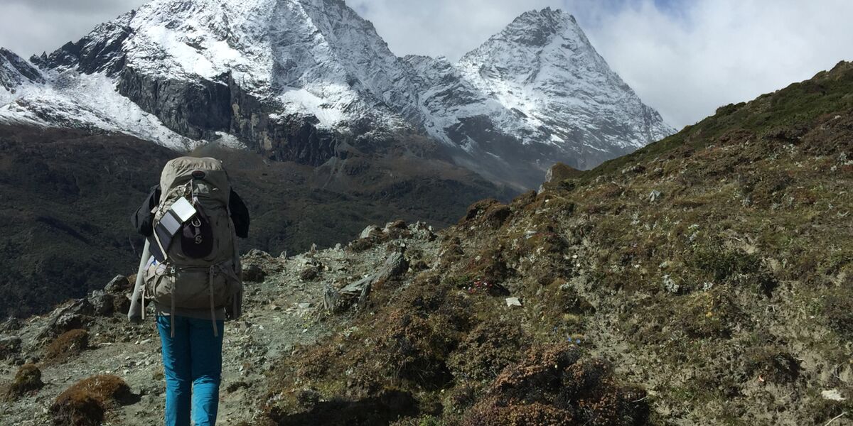
From the official entrance to the reserve, it is another 35 to 40 kilometers by bus to Yading Village and the heart of the park — with the ride included in the entry price. We disembarked near Chonggu Monastery, at the end of the bus line, and beyond which most of the day hikes and major attractions are located. We followed the tourist hordes toward the monastery and, once we reached it, continued about 500 meters along the newly constructed boardwalk through Chonggu Meadow.
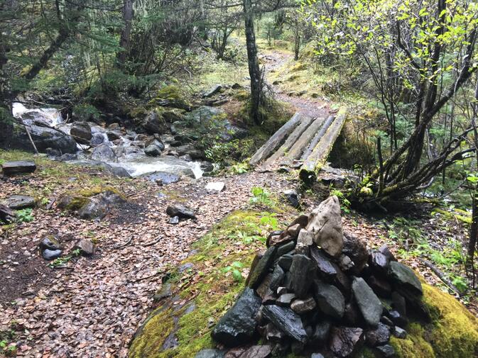
As soon as we were able, we cut left onto the road — which is supposedly reserved for the electric tourist cars heading to Luorong Pasture — and walked another 100 meters or so to the beginning of the trail. For a major hiking route, the trailhead is incredibly nondescript — a small stone with faded Chinese characters marks the beginning on the left side of the paved road, and the narrow trail slopes gently away and into the forest.
It runs parallel to the road for a short while, and then begins to climb steeply up the mountainside. About 20 minutes in, we crossed a stream via a small wooden bridge and, thanks to the good graces of a few other blogs we had read, we knew we were on the right path.
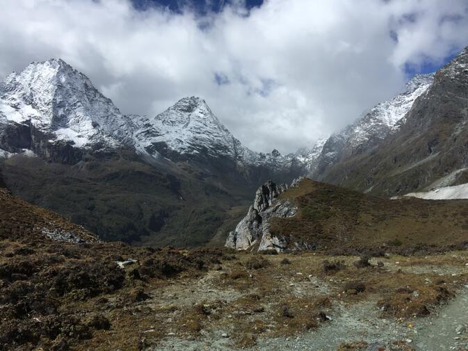
From the wooden bridge, it was slow and steep going through the lush, mossy forest for perhaps another hour of hiking before we gained a ridge that brought us above the tree line. From there, it was a straight shot into the wide, brush-filled valley that ascends towards the first pass of the trip. We soon came upon a small open pasture called Baiyu Camp, where we ate lunch.
We had heard that on a clear day, you can see all three holy mountains from Baiyu Camp, but our luck had not yet materialized, as the rain had begun first thing in the morning and returned in intermittent spurts throughout the day. Even so, the weather was not able to hide the vibrant beauty of the Yading Valley.
The swirling mist danced between sheer cliffs and grassy meadows while the mountain peaks hid behind thicker clouds above. A couple of lesser peaks revealed themselves as we climbed, and each water break along our hike turned into a ten-minute rest as we gawked at our surroundings. Even in partial visibility, the mountains were entirely captivating.
After lunch we continued our leisurely climb up the breathtaking valley for another hour before making an early camp. We were already at 4,600 meters and were worried about ascending any more on our first day of hiking. We hadn't been able to find any Diamox before our journey, but in Shangri-la (香格里拉) we did pick up what appeared to be a Chinese herbal medicine designed to prevent altitude sickness called hongjingtian (红景天). Unsure of its effectiveness, however, we decided not to push our bodies any more than we needed to.
Baiyu camp is a popular place to rest for the night, but it makes for a rather short first day, and there are numerous meadows more than suitable for camping between there and the pass. For intrepid hikers looking to cover more ground, the other side of the pass contains a similar number of camping locations.
Soon after setting up camp, the sun made its short-lived debut before giving way to a peaceful snowstorm, which continued on and off for the remainder of the evening. We were both delighted, albeit slightly wet, and we cooked dinner inside of our tent vestibule as the occasional snowflake drifted into our spaghetti. The night passed fitfully, perhaps due to the altitude, but overall we experienced little to no symptoms of acute mountain sickness. With the help of a little Traditional Chinese Medicine, we were well on our way towards acclimatization, our first major test of the trip.
Day 2: 13-15 kilometers, 400 meters of elevation gain, 900 meters of elevation loss
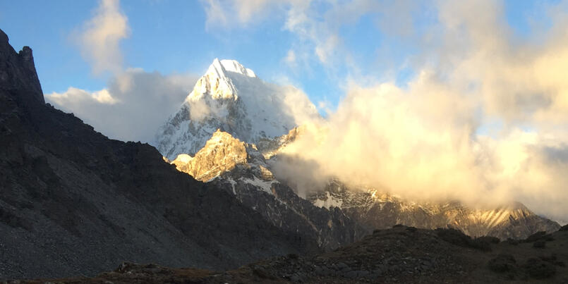
Our first morning in the mountains began with clear skies and fresh legs. Across the main valley, the summit of Chenrezig — the tallest of the three holy mountains at 6,032 meters — came out from its hiding place among the clouds. The peak looked harsh, snowy, and unfathomably large even from our distant vantage point. It was difficult for us to believe that it had been there the entire previous day and was simply obscured from view.
Yet there it was, greeting us with the morning sun, unchanged and unmoving. The first morning in the mountains is always my favorite — it's as if you have entirely forgotten your surroundings in the night, and upon seeing them again in the morning, every positive feeling from the previous day hits you all at once. It was with these feelings of awe and giddy excitement that we began our first full day of trekking.
The hike from our campsite to the first pass of the trip took about an hour and a half. Verdant meadows and alpine streams enveloped the well-defined trail, and snow-dusted peaks hovered around us, giving shape to the blue sky behind them. The ambience was that of a truly vibrant alpine ecosystem, a feeling that was reinforced when a small Moupin pika emerged from the talus to examine us while taking a water break.
Pika, apart from being insanely cute, are especially vulnerable to changing environmental conditions, so we were glad to see that there is at least one making a stand. When we crested the pass, we were at the highest elevation of the trip, and our lives — 4,900 meters. We were above the snow line for the first time, and thankful for the calm conditions that morning. It would be a truly unpleasant place to be in tumultuous weather.
On the other side of the pass, the trail descended into a misty valley that felt like another world. It continued along a gradual descent for about five kilometers before reaching a small village of nine stone yak-herding huts. We crossed paths with two hikers going the other direction, the only people we had yet encountered save for two local Tibetan women and their small caravan of mules.


The first hiker told us they had come from Lugu Lake (泸沽湖) and were on their sixth and final day of hiking. We expressed admiration and said that we wanted to make that trek in the future, to which he responded negatively. It turned out they had gone two full days without food because they couldn't find anywhere to resupply, and we surely wouldn't be able to either. We told him that we were carrying all of our food and offered him some, but they no longer needed any.
We wished him luck and continued, astonished at the dangerous predicament they had found themselves in before encountering his hiking partner. His first comment was to ask why we didn't have any trekking poles or knee braces — necessary items in his opinion. When we said we didn't like to use them, he seemed to imply that we were somewhat reckless and even went so far as to offer us his own. I guess people have different notions of preparedness. We took the interaction in good faith and continued on down the increasingly foggy valley.
On the other side of the village, the trail split. We took the right fork and began the steeper descent towards the valley beneath Chenadorje, another of the holy peaks in the area. This is the only point on the entire trek that we were confused as to which way to go, but a local quickly pointed us towards the correct path and our GPS soon confirmed his directions. From there, the stream to the right of the trail turned into a sizable waterfall that soared into even more engulfing fog below.

The trail kept left to switchback down the sharper decline. At the tail end of the rainy season, this path had effectively redirected the cascading water from above and became a stream of its own. As such, the rock-hopping and precipitous footing made for much slower going down this section. Soon we came to a wooden bridge at the bottom and crossed the main stream beneath the waterfall.
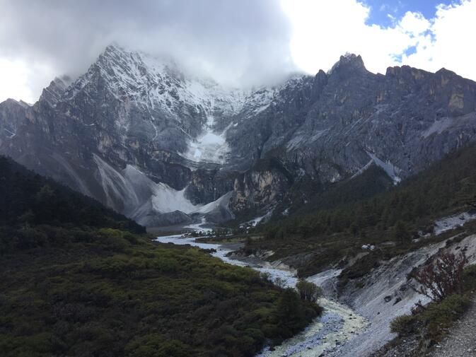
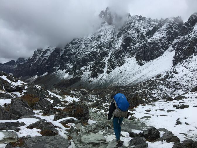
From there, the environment changed rather dramatically. After ascending a short hill on the other side of the bridge, the trail curved down and to the west through a saturated, dense pine forest. Undoubtedly this would be a beautiful section of trail in warm weather, but our spirits had dampened along with our feet. Now, entirely socked-in by fog, there were no amazing views to neutralize our discomfort. Nonetheless, the muddy trail passed rather quickly, and after another 2.5 kilometers we were out in the open and confronted with the imposing eastern face of Chenadorje.
Like the previous day's peaks, the summit was buried in clouds. But the sheer, glaciated, 2000-meter cliff face more than satisfied our hunger for mountain views. Despite our tiring legs, we were drawn by the gravity of the massif through the stunning U-shaped valley. By 4:30pm we had reached our campsite in an open, green meadow beside the stark white glacial outwash plain. At 4,100 meters, the climate was more suitable for an evening outdoors, and we hypnotically watched the clouds dance around Chenadorje before turning in for another early night.
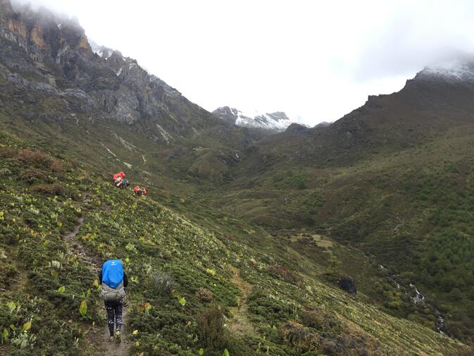
Day 3: 17 kilometers, 1,000 meters elevation gain, 850 meters elevation loss
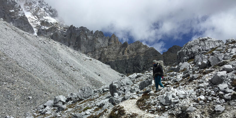
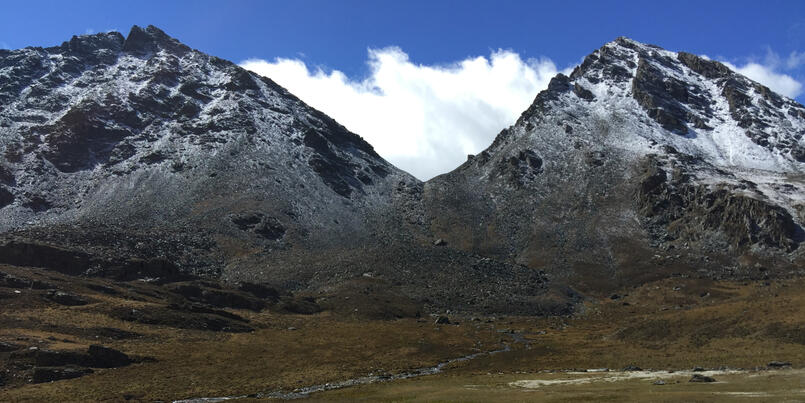
The third day of the hike was formidable. What we expected to be a challenging but doable day turned into a back-breaking, ten-hour slog over four mountain passes. We began hiking at 8:30am, traversing the remainder of the Chenadorje valley before climbing steeply up through a forest on the other side until we got back above the tree line to the first pass of the day. This smaller pass led into a modest hanging valley populated by a few stone huts. From there, the trail made a sharp turn to the right and up towards the second, slightly more impressive pass.
Although we had already climbed almost 500 meters, our legs felt strong and our lungs felt stronger. We both agreed that we much preferred walking uphill on a dry trail than walking on anything resembling the previous day's muddy path. At 11am we felt like we could have spent the whole day climbing passes. This was good, since that is exactly what we would have to do.
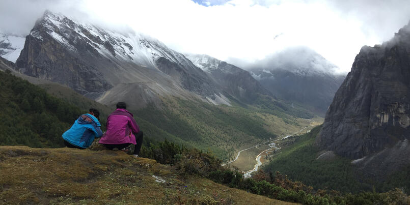
The fog dissipated as we gained elevation that morning, and the scenery from the second pass opened up into something truly unbelievable — a lush, glacially carved valley surrounded on every side by towering snow-capped mountains. A glistening river reflecting the peaks thousands of meters above. At the other end of the gorgeous valley was a steep, snowy headwall that looked quite impassable. We soon realized it was the next pass. The weather coming over the pass looked rather ominous, but we enjoyed the sunshine while we had it, hoping that it would follow us for the rest of the day.
The trail hugged the slope on the right side of the valley, and for about five kilometers made a gradual descent towards the foot of the pass. We were hit with a flurry of dry snow and hail around lunchtime, but it moved past by the time we began climbing. The trail quickly proved steeper and more difficult than the first two passes of the day, and our energetic optimism from earlier quickly faded. This was aided in part by an old Tibetan couple, likely in their 60s, who passed us cheerfully, quickly and easily.
When we eventually reached it, the top of the pass transformed into a surreal winter wonderland, and for the last few hundred meters we were trudging through a foot of wet snow. Despite the stark, harsh beauty of the barren high-country landscape, we weren't quite prepared for winter and hence did not linger at the top, quickly beginning our descent into the next valley.
It was already approaching 4pm, and we debated stopping earlier than planned. We had heard of hikers breaking up this longer day into two shorter ones by camping on either side of the third pass. There were certainly plenty of suitable areas to pitch our tent, but we were drawn by the promise of one of the most beautiful sights of the trip, a place called the 'amphitheater'. We decided that we had one more pass and a couple more hours left in us.
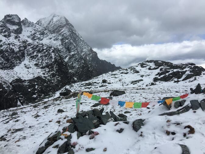
We refilled our waters and took off down the trail at a slightly faster pace, worried about losing daylight and motivated by the prospect of taking off our backpacks. The trail again clung to the right side of the valley for about five kilometers, traversing three large scree fields and passing a large stupa that marks the 'official' halfway point of the kora. It then ascended up a short but harrowing 200 meters towards a small notch between two dramatic cliff faces above and below. This was the fourth and final pass of the day.
Up until this point on the trek, we had been able to count the number of other people we encountered on one hand, which was our expectation coming in. However, the fourth pass contained an unexpected concentration of other hikers. We didn't give it much thought initially, focused on our goal of getting to camp before dark and catching our breath every ten steps. But when we finally reached the top of the pass and looked down towards our expected campsite, our triumph was met with astonishment.
Scattered amongst the green meadows and beneath the beautiful sheer cliffs encircling them was an expanse of multi-colored tents. From our heightened vantage point, we estimated that there were at least 100, certainly more than I had seen in one location in my entire life. Again, however, our minds and bodies had already been working overtime, and so we didn't have the mental capacity to give it much consideration. Despite being frustrated at our newfound lack of solitude and apprehensive about the environmental impact of such a large group, our interactions with everyone there were exceedingly pleasant.
We found a nice secluded meadow away from the larger group and made camp at 6:30pm, with just enough light left to cook dinner and clean up without much difficulty. The amphitheater had lived up to our expectations — the massive walls enveloped everything around us, and even provided a faint impression of security. For the first time on the trip, we slept under a cloudless sky, feeling a deep sense of exhausted accomplishment, and anxiously wondering what novelty the second half of the journey would bring.
Getting there
There are a number of different ways to get to Yading Nature Reserve, the easiest being to fly into the newly constructed Daocheng Yading Airport. At 4,411 meters above sea level, it is the highest civilian airport in the world. However, if your lungs, or your wallet, can't handle a direct flight to this remote Tibetan enclave, taking a bus is a viable and popular alternative.
A two-day bus trip from Chengdu, with a one-night stopover in Kangding (康定), is probably the most common route. We were starting from Kunming, and as such opted to first fly to Shangri-la, spend a night there to begin acclimatizing, and then take an eight-hour bus to Daocheng the next day. From Daocheng, it is another 1.5 hours by shared van or taxi to the town of Riwa. confusingly, Riwa has also recently changed its name to Shangri-la.
The entrance to Yading Nature Reserve, and the end of the public highway, is on the edge of this town. We spent one night there the day before beginning our trek. It is a good place to purchase camping fuel and stock up on some additional food. From there, we took a taxi to the entrance to the reserve early the next morning. The entrance fee to Yading is 270 yuan.

Images: Luke Dauner
© Copyright 2005-2026 GoKunming.com all rights reserved. This material may not be republished, rewritten or redistributed without permission.


评论
This is a great article! I feel as if I've been on a six day journey to a very magical place. (Only I don't have sore muscles!)
TK2018: Yes, I agree. Very nice writing, not just of the place but also of the experience. I envy the author this one. In reading the article I found myself remembering a few experiences I've had in similar mountain country decades ago (I hope this doesn't sound like boasting) and thinking the author and I had attained more or less the same plane, something we could share if we met - I could identify. Not everyone can express it this well.
Map, please!
Amazing! Just like TK2018 said, I could feel the emotions and challenges you went through. Great writeup, and great inspiration for some future hikes in China. Thanks for the article and thanks as always to Go Kunming for publishing!
Thanks for the great article. I'll be looking forward to part II.
We did the mini Kora in April and rarely ran into anyone else on the path beyond the Milk Lake. Apart from us, at the Amphitheater campsite, there were only another group of four hikers who came with a guide. They went in the opposite direction the next morning and we enjoyed having the place by ourselves for a few hours. I cannot imagine having a hundred other hikers camping there. That's absolutely crazy!!
We plan on doing the Big Kora one day. Your story is a wonderful inspiration indeed.
登录评论