


Editor's note: This is the second in a two-art series chronicling a week-long hiking trip through the Dulong River valley. The first installment was posted two weeks ago by contributor Sander Van de Moortel.
When the first morning fog clears off, we meet some Chinese tourists and agree to hire a driver together that will take us to Xiongdang (雄当) — the northern end of the road.
An anthropologist on a research trip puts us in touch with the local military officer, who assures us all trails but the main one are military domain and off-limits to foreigners. Our only option is to walk north to the Tibetan border and come back.

A strange little place
Xiongdang is a new village. The government has put in a lot of effort and money to build some sixty houses to accommodate village dwellers further north. All but a few die-hard villagers claim they're happy to move into a more modern town with a road connection. A little makeshift church provides religious services to those of the Protestant conviction.
Inside, chalk writings that look a lot like the Fraser alphabet presumably teach the word of God. The Fraser alphabet, though mainly used for the Lisu language, may have been exported by Lisu Christians evangelizing to their Dulong neighbors who have no script of their own.
The purchase of some fangbianmian from the local storekeeper-turned-parson gives us a reason to walk into one of the village's old wooden houses. It seems to act as the local pub as it's filled with people warming themselves by the fire, drinking soup or tea, eating noodles, or simply getting rosy on beer or baijiu.
The owner of the house is a welcoming lady who supplies us with a type of flatbread called baba, potatoes and information about the trails ahead. We learn that we can stay in any of the new, empty houses and we choose home number 59 for exactly that purpose.
The house, looking a little too much like a Swiss chalet, has never been occupied. The wooden floorboards still shine with varnish and we quickly realize why no one lives here — electricity and water haven't been connected, and the house lacks a bathroom and a kitchen. Such facilities are expected to be added sometime in the next year.
In the meantime, people cook and wash outside or stay in their older wooden huts downtown. For us campers, the five-room chalet serves just fine. A drizzle sets in while we're cooking our noodles and we pray for better weather the next day.

Into the wild
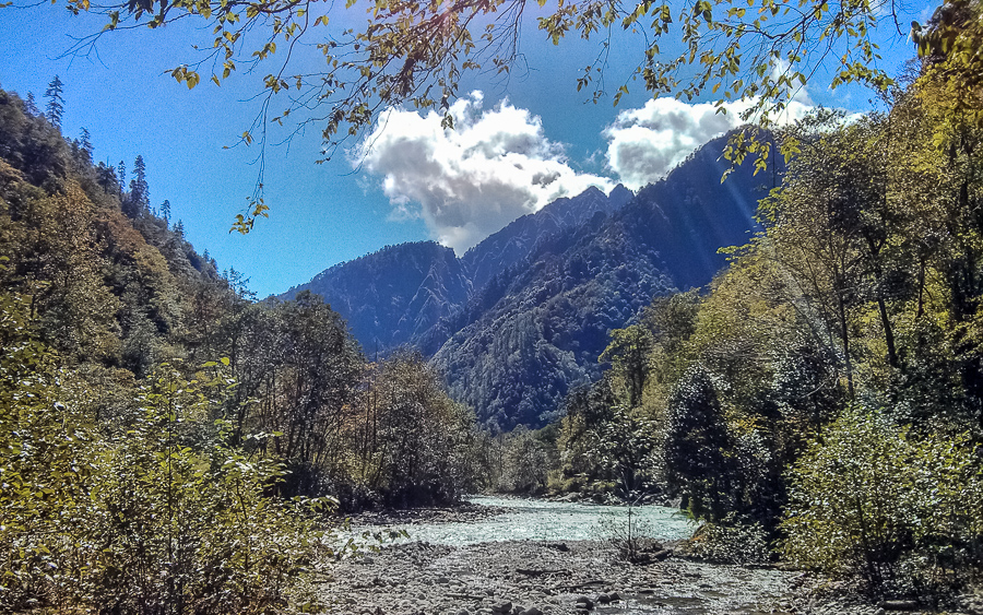
Our prayers have been heard and we wake to some of the most perfect blue skies in a long time. The hillside forest generates small clouds but the dapper morning sun burns it all off. Blessed by this excellent weather, we start the hike towards the Tibetan border with a first stop in the village of Ban (班).
The hamlet is tenuously connected to the power grid via a long wire strung all the way from Xiongdang and features scarecrows made of old shirts. The town dogs are most unwelcoming, so we limit our visit to a few pictures, some 'hellos' and then move on. The trail is littered with rocks and tree trunks, with bridges made of thin logs and moldering planks, sometimes provided with an improvised handrail.

One bridge looks like it was designed by August Möbius after a heavy night of drinking and then repaired by a young Salvador Dalí with a spool of iron wire. Beneath us rage small rivers. We have to watch our every step and be thankful it isn't raining.
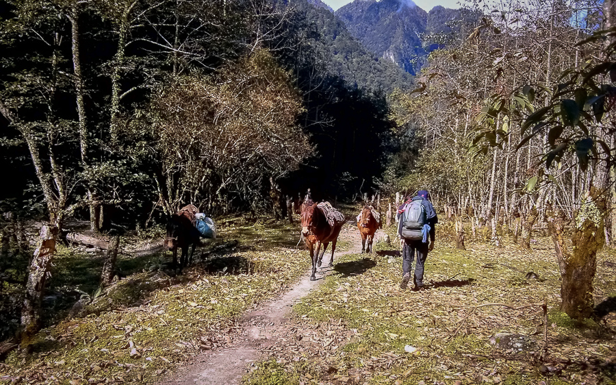
The rest of the trail keeps following the river, however difficult the terrain alongside it. Every now and then we encounter a group of people — the women and horses invariably loaded with heavy baskets, the men wielding machetes and slingshots to shoot unsuspecting birds. While most of the fauna wisely stays hidden, the flora is fantastic.
Mushrooms ranging from pizza toppings to those that will land you a night at the DEA office sprout up everywhere and the trail is strewn with wild strawberry patches of the inedible kind. Every now and then, a jay flutters up from out of the bush.

Eventually we arrive at the forgotten village of Jiayong (加涌). Because it only consists of a single log cabin, we fail to realize it is the day's goal. We move on to Shidang (石档), the next inhabited place, which is yet another collection of deserted log cabins surrounded by large cannabis trees.
The northern Dulong people obviously build homes for colder weather than their tropical southern kin, whose huts are mainly made of bamboo. The cabins seem deserted and we decide to take shelter inside. The dwelling is littered with cups and other trash with some blankets around the fireplace. We wonder if someone still lives here, or if only tourists and traders use the place as a shelter. After making a fire, we're snoring the night away.

A dream of monkeys
When we wake up the next day, the skies are overcast and a light drizzle dampens our moods. We know we can reach the Tibetan border and be back in one day, so we decide to leave our backpacks in the cabin. Without the extra luggage, we swiftly skip along the trail towards Nandai (南代) — a larger village with a small but active population, slightly exceeded by the number of bark-happy dogs.
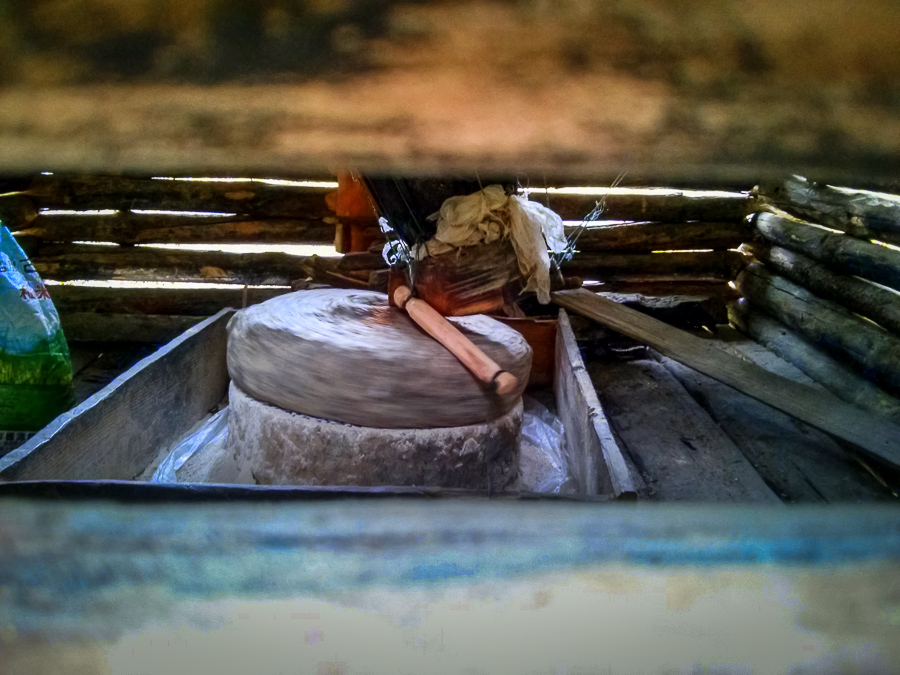
All houses are constructed with wooden boards and logs and the main industry seems to be the weaving colorful mats with self-sustaining farming taking up much of the rest of the residents' time . On its way to the river, a small side stream powers a mill house in which a grinding stone produces flour and oil.
When we begin asking for directions to the border town of Dibuli (迪布里), a scruffy man, with two snot-nosed toddlers, appears from a doorway. His wife speaks rusty Mandarin and walks us towards the beginning of a trail. The villagers obviously haven't had a bath for many days and we wonder where they get their synthetic clothing from.
After Nandai, more slippery bridges over side-streams make the hike a hazardous enterprise. The trail is marked by ever-fewer shoe tracks and we repeatedly walk up dead ends, losing plenty of time. Since the trail is meticulously cut through thorny bramble, taking shortcuts is not an option.
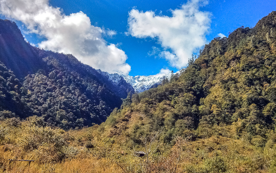
According to our GPS, we're only a few hundred meters away from the Tibetan border when the trail transforms in a series of rickety ladders supported by even more rickety branches. Everything is barely held together by moldy bark. Daylight is quickly burning, so we decide it's not worth the risk to go on. Instead we turn back, planning on moving our stuff to the first shelter.
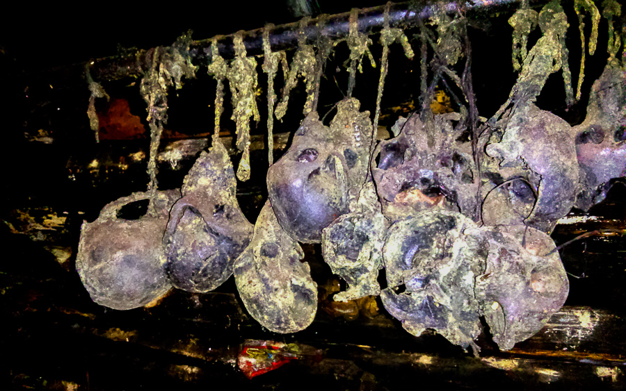
In the glow of our campfire, we make a lugubrious discovery inside the cabin. Dangling from a log is a set of monkey skulls covered in green fungus. An anxious glance at the clock reveals it is just past midnight on Halloween. We sleep an uneasy sleep.
A cheery engineer, in decidedly non-local clothing and backed up by an entourage of porters, greets us on our way back the next morning. They're on a prospecting mission for a new dam site. If the controversy around the Nu River (怒江) dams continues, the Dulong may yet be the first of the two to get dammed. This is a possibility hastened by the river valley's relatively small population, most of whom have already moved to new government-built villages. Any protests will most likely remain small.

Back to reality
Back in Xiongdang we find the 'pub' filled with young girls from nearby mountain villages. Our gifted chocolate goes down well with the girls, while the men are pleased with a case of beer. After we make clear we're not Protestant — and therefore apparently permitted to drink — we all get a warming shot of baijiu and convivial conversation ensues.
The girls thank their excellent Putonghua to their education in Gongshan (贡山), which used to be a three-day walk from their home before the road was built. Some have made it all the way out to Shenzhen for work. Trying to discuss the monkey skull matter, however, makes everyone fidget uneasily, so we decide not to ask any further.

We walk to the artificial village of Dizhengdang (迪政当) and arrange a minivan to Kongdang. The distance is a mere 30 kilometers but the driver stubbornly wants 300 yuan, explaining that petrol costs ten yuan per 500 grams of petrol. We've never heard petrol expressed in weight units, but we're happy when the van pulls into Kongdang.
Because it's the weekend, all hotels are full so we have to make do with a room containing three beds built out of woven bamboo. It's unfortunately right next to the local disco/motorcycle-with-speakers. All tickets for the next morning's jeeps to Gongshan are sold out, too, so we end up hanging around town.
In the ticket shop, a group of girls from Myanmar are eying the smartphones on display. They're a young teacher and her Rawang minority students. In fluent English, she explains they have walked several days to come here and will be going back first thing in the morning.
We think it's a remarkable thing and the shopkeeper, who speaks their language, agrees and proceeds to show off his knowledge of the world, praising France and Germany for reprimanding the United States over the NSA eavesdropping scandal.
After a while, we manage to find a van and seven passengers who together generate the requested fee of 700 yuan. The pass is covered in snowy sludge and we learn that it will be one of the last weeks before the road is officially sealed off for the winter. A salesman of agricultural machines we meet later in Liuku has brought a backpack with supplies. If he ends up getting stuck without transportation, he will make the four-day hike out through Tibet and back down via Bingzhongluo (丙中洛).

Getting there
Getting to the Dulongjiang is a lengthy and complicated enterprise, taking up to three days. The longer duration trip involves a day bus leaving for Liuku from the Kunming's West Bus Station (西部汽车站) for 200 yuan. The ride takes eight to nine hours including stops. Another option is to skip to Liuku and take the night bus straight to Fugong for 240 yuan. That bus departs at 4pm and 6pm.
We prefer the former because Liuku is a nice place with a mountainside boardwalk, a pedestrian riverside zone and agreeable temperatures. In Liuku you can stay at the comfortable Gerui Hotel (格瑞大酒店) for 135 yuan per night, including breakfast — call 0886 388 8885 for reservations. The bus station is in the new part of town, which will require a taxi ride of around 15 yuan from the hotel.
Buses to Gongshan leave every 30 minutes from both the Liuku or Fugong bus stations. The ride from Liuku to Gonshan takes eight hours and tickets cost 71 yuan. From Fugong, the trip is roughly four hours and a tickets costs 50 yuan. In Gongshan both the Tongbao (通宝大酒店) — call 0886 351 3339 — and Xiagu (峡谷大酒店) — call 0886 351 1666 — hotels offer comfortable double rooms for 100 yuan and are within walking distance of the bus station.
Buy your jeep ticket for the morning — 7:10 or 9:10am — to Kongdang in the shop next to the government building for 60 yuan. The ride takes four to five hours until the new tunnel is completed at the end of 2014.
Before the completion of this tunnel, the road will also be sealed off from mid-November to mid-March due to heavy snowfall. In Kongdang you can get a reasonable double room at the Daping Hotel (大平酒店) — call 13988696984 — for 60 yuan. On weekends, the few hotels quickly fill up so make reservations in advance.

Images: Sander Van de Moortel and Matthew Hartzell
Map: Matthew Hartzell


Comments
Were any live monkeys spotted? It wasn't mentioned but they must be around ( or were around )
Thanks for the very informative article!
We didn't see any live monkeys but for the one having a good time counting his legs near the Myanmar border (see part one). I think they're mostly shy outside of parks where tourists give them food or an opportunity to steal. Sneaking up the hills in the northern section, you may catch some snub-nosed monkeys.
Thanks for this travelogue! Does anyone have any info on the hike from Bapo to Gongshan? How long does it take? Is it very hard to cross the Gaoligong Mountains? Is a tent & stove necessary for this trek or are there some villages on the road? How far is it? Thanks!
Unfortunately we have not a lot of information on this walk; but there are people who do, such as A Luo (in Bingzhongluo). All we know is that you need to know the trails very well, that you'll have to camp or stay in shelters (no real villages) and we can estimate that it'll be a two to three-day walk.
Mountains are _very_ steep so if you end up on the wrong trail you may have to turn back unless you want to risk your life. It'd be an interesting thing to do if you have a tent, time and a GPS.
Thanks bluppfisk. How can I contact A Luo in Bingzhongluo? Is he a tour guide? The hike you did sounds a bit more easy and accessible... Cheers.
@Ma Xiansheng
In 1997 a documentary was filmed 《最后的马帮》("The Last Horse Caravan") about the muleteers who made the trek between Gongshan and Bapo just before the road made them obsolete. You can view this beautiful and fascinating documentary free on cntv here: tv.cntv.cn/video/C39847/c2c79bc6e9a14e559a883d9b26f6f390
It should give you a good idea of the what the trail is like.
Remember, this documentary was filmed in 1997, when the trail was still in use every season. Even then, it was very difficult. Imagine now, when it no longer serves an economic purpose. According to sources in Gongshan, it is still possible to hike, but it has fallen into disrepair. Most likely, landslides which have made parts of it tricky.
The trail itself should be fairly easy to follow as it is wider than a normal hiking trail (it was built by the CCP in the 50s-60s for the mule caravans).
There are NO villages along the way, but there are campsites and shelters. You can find a map of the trail on my blog: matthartzell.blogspot.com/[...]
Ok thanks for the information - sounds good!
Login to comment